
Red Sea on the Map: Location, Size, History & Why It Matters
When you look at the Red Sea on the map, you’ll find one of the most important and fascinating bodies of water on Earth. Stretching between Africa and Asia, the Red Sea has played a major role in global trade, ancient civilizations, and marine biodiversity for thousands of years.
In this guide, you’ll discover where the Red Sea is located, how big it is, why it’s called the Red Sea, and why it remains strategically and environmentally important today.
Where Is the Red Sea Located on the Map?
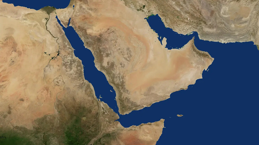
Finding the Red Sea on the world map is easy once you know its position. The Red Sea lies in Northeastern Africa, forming a natural boundary between Africa and the Arabian Peninsula.
Red Sea Location Highlights
-
Western coast: Egypt, Sudan, and Eritrea
-
Eastern coast: Saudi Arabia and Yemen
-
Northern end: Gulf of Suez and Gulf of Aqaba
-
Southern entrance: Bab el-Mandeb Strait, connecting to the Gulf of Aden and the Indian Ocean
Geographically, the Red Sea stretches roughly from 12°N to 30°N latitude and 32°E to 43°E longitude. Its location makes it a critical maritime corridor especially due to the Suez Canal, which links the Red Sea to the Mediterranean Sea.
How Big Is the Red Sea?
Many travelers and geography enthusiasts ask: How big is the Red Sea? The answer highlights its impressive scale.
Red Sea Size & Dimensions
-
Length: About 2,250 km (1,400 miles)
-
Width: From 26 km at Bab el-Mandeb to 355 km at its widest point
-
Average depth: Around 490 meters
-
Maximum depth: Approximately 3,040 meters
-
Surface area: Nearly 438,000 square kilometers
To put its size into perspective, the Red Sea is larger than California and comparable to the size of Iraq. Despite its narrow shape, it holds an enormous volume of water and features dramatic depth variations that support diverse marine ecosystems.
Why Is It Called the Red Sea?
The question “Why is it called the Red Sea?” has puzzled historians for centuries. Interestingly, the water itself isn’t red. Several well-supported theories explain the origin of the name.
1. Algae Blooms
One scientific explanation links the name to Trichodesmium erythraeum, a type of algae that occasionally blooms and gives the water a reddish-brown appearance.
2. Ancient Directional Colors
In some ancient cultures, colors represented directions. Red symbolized the south, and since the Red Sea lies south of the Mediterranean, it may have been named accordingly.
3. Red Mountain Reflections
The surrounding mountain ranges especially on the Arabian side contain reddish rocks. At sunset, these mountains can reflect a red glow onto the sea.
4. Linguistic Evolution
The name may also stem from the Greek term “Erythra Thalassa”, meaning Red Sea. Over time, translations and interpretations may have altered the original meaning.
Why the Red Sea Is So Important Today
Looking at the Red Sea on the map clearly explains its global importance—not just historically, but also economically and environmentally.
Global Trade & Shipping
-
Around 12% of global trade passes through the Red Sea via the Suez Canal
-
One of the world’s busiest shipping routes connecting Europe and Asia
-
Vital for oil transport, cargo shipping, and cruise tourism
Marine Life & Biodiversity
-
Home to 1,200+ fish species
-
Over 200 coral species
-
Many species are endemic, found nowhere else on Earth
-
Exceptional water clarity and warm temperatures year-round
Tourism & Diving
Popular Red Sea destinations include:
-
Hurghada & Sharm El Sheikh (Egypt)
-
Aqaba (Jordan)
-
Eilat (Israel)
These locations are world-famous for scuba diving, snorkeling, coral reefs, and luxury beach resorts.
Unique Features of the Red Sea
Beyond its location and name, the Red Sea stands out for several remarkable characteristics.
High Salinity
The Red Sea is one of the saltiest seas in the world due to:
-
High evaporation
-
Minimal rainfall
-
No major rivers flowing into it
Geological Activity
The Red Sea is geologically young and still expanding as the Arabian Plate slowly moves away from Africa. It widens by about 1 cm per year, making it a living example of plate tectonics.
Underwater Hot Springs
Hydrothermal vents on the seabed release mineral-rich, heated water, supporting rare microorganisms and forming colorful mineral deposits.
Conclusion
When you explore the Red Sea on the map, you’re looking at far more than a body of water. You’re seeing a region that connects continents, supports unique marine life, drives global trade, and holds deep historical significance.
Understanding how big the Red Sea is highlights its massive scale, while uncovering why it’s called the Red Sea adds mystery and cultural depth. From ancient trade routes to modern tourism and marine research, the Red Sea continues to shape our world in powerful ways.
Whether you’re a traveler, diver, student, or geography enthusiast, the Red Sea remains one of Earth’s most extraordinary natural wonders.
